Local
history
 |
Photo: Ely Cathedral
by June Francis.
|
In the 1960s there were people living in Surbiton Park who had memories of the area as it was in the late 19th century. Stories were told about various events in the history of the area.
The purpose of this page is to assess the probability of the truth of some of these traditions.
The S-shaped Strip
There had been a plan to build a new road south of Uxbridge Road, but this scheme was abandoned when Catherine Road, Surbiton was built, and the land was sold off in small plots.
-
This is essentially true, but the timing of the various elements of the story needs to be understood.
On maps of several different periods it is possible to see a strip of land with a gentle reverse curve, running roughly west to east immediately south of Surbiton Park.[1]
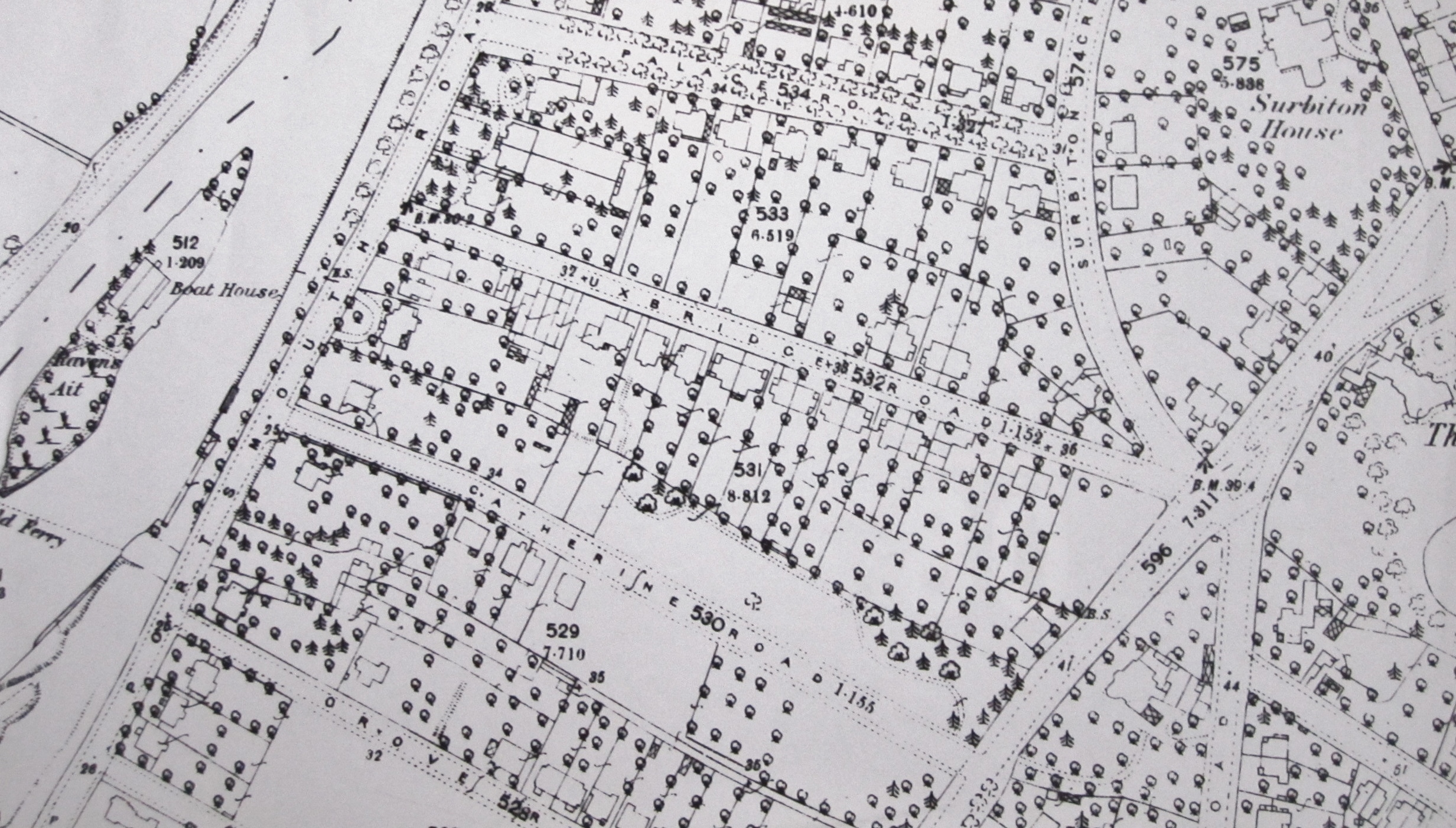
Detail of Ordnance Survey 25in. map 1865, with S-shaped strip between
Uxbridge Road and Catherine Road (Photo: LynwoodF)
In his original plan for his Surbiton development, Thomas Pooley showed a road on this strip which would give access to the Portsmouth Road.[2] The junction would not have been directly opposite the end of the present Claremont Road, because the park of Surbiton Place was in the way and the strip was the nearest available land.
Pooley got into financial difficulties and his scheme was never completed.[3] Once William Woods had built Uxbridge Road, there was a more direct route to the main road and the river. The building of Catherine Road finally put paid to the idea of a road on the strip.
Therefore, the strip was sold off in relatively small plots. The predecessor of the present Ravenside[4] was built on Portsmouth Road, and the fancifully named Eastfield[5] was built in Maple Road on the site now occupied by Home Court.
The remainder of the land was sold to the owners of houses in Uxbridge Road to lengthen their gardens. The land was in Surbiton and it was part of the folklore that an additional amount of rates was paid to Kingston and passed on to Surbiton, until the amalgamation of 1965 brought an end to this anomaly.
The strip can still be discerned on the Ordnance Survey 1:1,250 map (the "50in. map").
The Tram Route
The tramway was routed via Surbiton Crescent as a result of pressure from the occupant of Surbiton Hall.
-
This could very well be true. Mrs Shrubsole was a member of a prominent family in Kingston, one of whom, Henry, served as mayor three times.[6] No doubt she had the ear of councillors.

Kingston Market Place with memorial to Henry Shrubsole (Photo: Colin Smith)
Examination of the 50in. map shows that the tramway company would have preferred to take the route via the gentler turn into Maple Road and the very gentle turn into Claremont Road.
However, Mrs Shrubsole would not have wanted to have clanking, screeching trams passing in front of her home every few minutes.[7]
Alignment of Houses
The 1930s houses in Surbiton Road were built at an angle to the road in order to reflect the orientation of Surbiton Hall.
-
If this was ever a stated aim, it was a case of making a virtue out of necessity.
The 50in. map shows that the boundaries of the curtilages are parallel to the existing wall at the northern end of the site, the one with the plaque mentioned in the History section of the Wikipedia article. Since the houses are semi-detached, it is a practical necessity for the side walls to be parallel to the curtilage boundaries.

The plaque (Photo: LynwoodF)
In addition, the arrangement allows the house at the corner, 157, Maple Road, to have a reasonably sized rear garden.
Sources
Richard Statham: Surbiton Past. (Phillimore, Chichester, 1996).
Shaan Butters: The Book of Kingston. (Baron Birch, 1995).
John Pink: Two Roads in Victorian Surbiton Glimpsed from the Census Returns 1861-1891. (JRP, Surbiton, 1996).
Notes
1. See e.g. Pink, Grove Road section, first three maps.
2. Statham, p.25 - see map. The strip is shown separately at the top.
3. Statham, p.26ff.
4. This name appears in the 1905 Kelly's Directory.
5. The area was historically known as ''West Field''. See Pink, Westfield Road section.
6. Butters, p.132.
7. Statham, p.83.

 Uploading ....


